Thursday, September 29, 2016

JOURNAL OF THE CHENANGO COUNTY HISTORICAL SOCIETY SEEKS AUTHORS

JOURNAL OF THE CHENANGO COUNTY HISTORICAL SOCIETY SEEKS AUTHORS

Hot off the press! The 2016 issue of the Journal of the Chenango County Historical Society was published on September 14 and can be purchased at the Museum gift shop. This is our fifth annual issue and the readers should enjoy it.

But now we are recruiting authors for our 2017 issue. If you know something about local history that other folks might also like to know, consider being an author. We are seeking original material that has never before been published. If you are knowledgeable but are hesitant about writing, not to worry. We can pair you with a writer, or turn you into one. We are trying to preserve history before it gets lost forever. Knowledge must flow from those who know to those who do not know. If you have any questions, contact me through the Museum.

Donald A. Windsor 

====

JOURNAL OF THE CHENANGO COUNTY HISTORICAL SOCIETY SEEKS AUTHORS


JOURNAL OF THE CHENANGO COUNTY HISTORICAL SOCIETY SEEKS AUTHORS

Hot off the press! The 2016 issue of the Journal of the Chenango County Historical Society was published on September 14 and can be purchased at the Museum gift shop. This is our fifth annual issue and the readers should enjoy it.

But now we are recruiting authors for our 2017 issue. If you know something about local history that other folks might also like to know, consider being an author. We are seeking original material that has never before been published. If you are knowledgeable but are hesitant about writing, not to worry. We can pair you with a writer, or turn you into one. We are trying to preserve history before it gets lost forever. Knowledge must flow from those who know to those who do not know. If you have any questions, contact me through the Museum.

Donald A. Windsor 

====

Saturday, September 24, 2016

ABANDONED ROADS IN OTSELIC


ABANDONED ROADS IN OTSELIC

Donald A. Windsor

Most of the roads that appear on early maps are still being used today, greatly improved of course. There were more roads in the past than there are now, because many were abandoned and only a few have been added.

Abandoned roads make good hiking trails, especially those that are regularly used by all-terrain vehicles and snowmobiles. Some of these abandoned roads have old stone foundations alongside them. The photo shows one in the Town of Otselic. The dotted lines in the 1885 topographic map below indicate a poor road. The black squares depict residences.


On our Bullthistle Hikers trek on Sunday morning 18 September 2016, we looked for additional foundations, but could not find any. The understory foliage was too thick. We will try again during the upcoming winter, when the leaves are down.

====

Monday, September 19, 2016

HUNTS MOUNTAIN, SHERBURNE NY


HUNTS MOUNTAIN, SHERBURNE

Donald A. Windsor

Hunts Mountain is that big hill southeast of the Village of Sherburne, the one with the tall tower topped with a flashing light. Its pinnacle is 1880 feet elevation. The Village elevation is 1055 feet. (1). Hunts Mountain was the highest point in the Town of Sherburne, until 1853, when Sherburne annexed the area around Skinner Hill from the Town of New Berlin (2). Skinner Hill has an elevation of 1960 feet (1). So, now Hunts is second to Skinner.


The pinnacle was marked by the United State Geological Survey in 1942 and is quite visible. It has three ancillary markers with arrows in their medallions pointing to the pinnacle marker. Two are quite visible but the third is overgrown by vegetation. Photo below is by Maryann Weiss.


This hill is all privately owned, but we Bullthistle Hikers were fortunate that one of the landowners, Allen “Al” Marsters, led us on a vigorous hike on Sunday morning 11 September 2016. He took us up, down, and all around, showing us some interesting sights and explaining their backstories. We covered about 5 miles.


Hunts Mountain was named after an early settler, Milo Hunt. He was probably not the first settler because he was born in 1793 (3). Baker (4, page 1) claims that he settled here between 1795 and 1800, but he would have been a child then. Baker does say that the Swan family settled here around 1795 (4, page 2). Anecdotal information has Andrew Freeman as the first settler, but documentation remains elusive. Baker wrote a useful comprehensive history of the ensuing settlements and real estate changes. Milo Hunt was the Town of Sherburne Supervisor during 1829-1830 (6, page 454).

As a chronological benchmark, the first Euro-Americans known to enter the area that is now the Town of Sherburne were the surveyors for the 1789 survey of the Twenty Towns. Sherburne is Town 9. The first settlers arrived in either 1791 (5, page 8) or 1792 (5, page 46). The Town of Sherburne was first organized in 1795 as the Town of Paris in Oneida County (6, page 449) and established as Sherburne in 1798 when Chenango County was formed (6, page 71).


References cited:

1. United States Geological Survey topographic map Sherburne, N.Y. 1943 Revised 1994.

2. Windsor, Donald A. Skinner Hill. In: Souvenirs of Yesteryear. Exploring Chenango County, New York. Norwich, NY: SciAesthetics. 2010. Pages 16-18.

3. Anon. Christ Church Cemetery, Sherburne, NY. http://www.rootsweb.ancestry.com/~nychenan/chrstch.htm

4. Baker, Pete. History of Hunts Mountain. Handwritten unpublished manuscript November 10, 1992. 14 pages. Transcribed by Sandy Gutosky in June 2014. 9 pages.

5. Hatch, Joel, Jr. Reminiscences, Anecdotes and Statistics of the Early Settlers and the 'Olden Time' in the Town of Sherburne, Chenango County, N.Y. Utica, NY: Curtiss & White. 1862. 104 pages.

6. Smith, James H. History of Chenango County … Syracuse, NY: D. Mason. 1880. 500 pages.

====

Tuesday, September 6, 2016

OLD FOUNDATION IN LINCKLAEN

OLD FOUNDATION IN LINCKLAEN

Donald A. Windsor

Here is a photo of a stone foundation in the Lincklaen State Forest in its eponymous town. It is located on the east side of Hyer Road, just south of Springer Road. I took this photo on our Bullthistle hike Sunday 4 September 2016.


Notice that all four of its walls are caved in. This cellar hole is becoming a dimple in the forest floor. The usual process of disintegration is that the northern wall caves in first. The winter sun melts the ice in and behind it and then the water refreezes at night. This repetitive freezing and thawing ultimately collapses the wall. Next to come down are the east and west walls. Finally, the south wall caves in. The process is similar to folding up a donut box. The cellar hole becomes overgrown with vegetation and becomes camouflaged.

The 1855 map labels this foundation as belonging to H.C. Burdick. The 1863 map shows it as H.D. Burdick. Burdick is a common name in this area. Burdick Settlement, now Lincklaen Center, is up the road northerly about 2 miles. The Burdicks moved here in 1804 (Smith). The 1875 map has it as H.P. Marble. This foundation was probably built in the 1840s so it has been there for over a century and a half.

As a caveat, these maps were not drawn to an exact scale, so jumping from one to another is not an exact action, especially when there are name changes. House sites could remain constant but the houses could have been totally rebuilt.

Chenango County has many old foundations and the one featured here is just an example. Each foundation represents its own story. Unfortunately, most of these stories have vanished.

Reference cited:

Smith, James H. History of Chenango County. 1880. Page 483.

=====

Friday, September 2, 2016

STAR-NOSED MOLE IN SMITHVILLE


STAR-NOSED MOLE IN SMITHVILLE

Donald A. Windsor

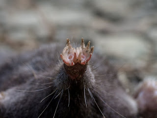
We have two species of moles in Chenango County, the Hairy-tailed Mole (Parascalops breweri) and the Star-nosed Mole (Condylura cristata). Both have hairy tails, but the Star-nosed has a long one. It also has a unique nose – 22 tentacle-like appendages surround its snout.

On Sunday 28 August 2016, we Bullthistle Hikers saw a dead Star-nosed Mole on Waldon Road in the Town of Smithville. It did not show any signs of trauma; it was just dead.


My notepad is 2 7/8 inches across. John Carhart measured the beast. It was 4 inches snout to tail and the tail was2 ¾ inches. John's close ups of the snout appear below.


This is our second Star-nosed in Smithville. The previous was on 2 October 2011 on State Route 41 through the Long Pond State Forest. It was smashed roadkill. On 15 March 2009 we encountered a live one running around on the grassy dam at Balsam Pond in Pharsalia. We enjoyed great views.

Star-nosed Moles live in moist soil, often near water. They eat earthworms and other invertebrates. They are good swimmers and can catch and eat small fish in muddy waters. The tentacles are sensitive tactile receptors and can sense electrical fields underwater.

Reference consulted:

Reid, Fiona A. Star-nosed Mole. In: A Field Guide to Mammals of North America North of Mexico. 4Th Edition. Boston, MA: Houghton Mifflin. 2006. Pages 389-390, Plate 34.

======