Wednesday, November 2, 2016

GROG HOLLOW MONSTER


  Grog Hollow Monster
Donald A. Windsor

So here we are, right up there with the big guys. Loch Ness has Nessie; Chesapeake Bay has Chessie; Washington State has Sasquatchie, and Chenango County has the Grog Hollow Monster, Groggy.

Grog Hollow is a complex valley fed by several streams and gullies which drain multiple hilly watersheds. It lies within the Wiley Brook State Forest along the eastern edge of Oxford, near its border with Guilford. The origin of the name "Grog" remains elusive. Perhaps it is an acronym for "Gruesome Repulsive Obnoxious Ghoul". Perhaps it is an old Indian name for "Land of the bull monsters".

The focal point of Grog Hollow is now a beaver meadow. It was a large beaver pond as recently as 2003, with six tiers of dams, but the beavers have been absent since. They may have been trapped out, but I suspect they left voluntarily. The aspen and alder, their favorite foods, had been exhausted and they were forced to cut hemlocks. Beaver habitat runs in multi-decade cycles. Beavers dam a forest stream. The water kills the trees and allows sunlight to enter and a thriving pond ecosystem develops with aspen and other deciduous woody vegetation along the banks. When these plants are depleted, the beavers leave. Their dams are no longer maintained, so they fall apart. The water flows away and a luxuriant meadow results. Eventually the trees return and the cycle repeats.

The Grog Hollow monster was first made public when Bob McNitt broke the story in "The Evening Sun" on Halloween 1979. He reported what some reputable good old boys told him of their close encounters with this creature. Right after dusk, one duck hunter heard loud pounding noises that moved closer and closer. Although he was an experienced outdoors man, well accustomed to being in the woods at night, these sounds he had never heard before. Smart guy that he was, he exited. Dogs were afraid to enter the area. No signs of raccoons were evident. A large beast was seen, but was not a coyote, or a bear, and did not seem to be a panther.

To investigate this matter, Bob and two of his intrepid buddies spent an unforgettable night in the abysmal darkness of Grog Hollow. He related their experiences in another article on the following Halloween. These two articles are required reading for any seeker of local monsters.

Bob's investigation deduced that the monster may have been a bear. At least, that is what his group encountered. They heard noises at the far side of the pond and moving around to their location. Two days later, in daylight, Bob found black bear belly hair nearby. Upon my asking how he could identify belly hair, he reminded me that he is an experienced taxidermist who is familiar with the belly of the beast.

In his 1980 article, Bob uncharacteristically admits that his hair-raising experience may have not been due solely to a bear. He cautiously mentions "psychic phenomena" and "a spiritual presence", even a "murder victim's ghost".

I have to concur. I do a lot of wandering around in the woods alone and enjoy what is normally a pleasant experience. But there are some places where I become obsessed with a strong urge to depart swiftly. Grog Hollow is one of those places. It is very easy to become disoriented in there and the place can be downright spooky when the sun is suddenly blocked by a cloud. It can be a bright sunny day with no clouds in a deep blue sky, but go into Grog Hollow and a cloud somehow appears and hovers ominously overhead. Bob warns that Grog Hollow is prone to hip high fog, which makes it seem even spookier at night.

Should you ever dare to spend the night alone in Grog Hollow, you will probably not be able to sleep. The strange noises, punctuated by eerie silence, will keep you awake. But toward the long anticipated dawn you may doze off. When you do awake, the first rays of muffled light will illuminate the mysterious haze and you may not be able to see Groggy, but you will certainly feel groggy. And should you have imbibed a bit too much grog the evening before, you may awaken to a monster of a pounding headache.

Every year or so, we Bullthistle Hikers venture out onto the beaver meadow to search for Groggy. Unfortunately, or fortunately, we were not privileged to witness the monster. Perhaps Groggy departed with the beavers. Perhaps Groggy ate all the beavers. Perhaps Groggy has a craving for hikers, with a side order of bullthistles. Perhaps Groggy wants his order super-sized.

However, one time we did have a scary encounter with the Grog Hollow Monster. All's well that ends well. But for a moment, we thought we were doomed.

It was a glorious Easter morning, March 23, 2008. We had just finished a joyous sunrise service on the aptly named Gospel Hill Road. We were a small band of intrepid Bullthistle Hikers out to explore the notorious Grog Hollow. All of our previous searches were uneventful and we expected this one to be also. However, this year we hit the jackpot. Here are the harrowing details of our death-defying adventure.

As we cautiously approached the extensive beaver meadow that nestles in the Hollow, we marveled how spooky the dead trees looked, even in the bright early sunlight. The snow covering the wetland looked like white frosting on a cake. The trunks of the dead trees resembled candles. The previous day was my 74th birthday and I, proud of my status as an old geezer, was counting the "candles". My hiking buddies had paused for a refreshing slug of stale coffee and some yummy bunny-shaped sweetie cookies. We were enjoying the eerie silence of this mysterious plot of treacherous wilderness.

But then we heard a soft crunching sound on the forested edge of the frozen marsh. We all glanced in the direction of the ever louder crunches. Soon we heard the wheezing snorts of deep, heavy breathing. The unseen source was rapidly advancing towards us. Perhaps it was a bear... But then we remembered where we were and what it could be -- the dreaded Grog Hollow Monster!

I whipped out my trusty camera as we all stayed quiet, guardedly apprehensive but uncharacteristically silent. Then it appeared. It was indeed the fearsome monster. We were the luckiest, or the unluckiest, folks in the county, for we were the first people to ever witness this startling sight.

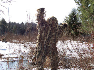
There it is in the photo. Note that it seems to be an animated outgrowth of the ominous swamp itself. Its long unruly hair seems lavishly festooned with aqueous vegetation. It reeked of marinated carrion. Although we could not see its eyes, we felt as if this fearsome beast was watching our every movement and glaring into our brazen souls.


Suddenly, the Monster pounced on one of our terrified hikers and was dragging her into the woods. I took a photo and yelled at it to let her go. To my astonishment, it did. But then it turned on me. I started running away.


When escaping from the clutches of a monster, you do not have to run faster than it -- just faster than the slower runners behind you. As I was photographing the monster, my fearful colleagues had already run away. I was the one behind. It was just the two of us, stalwart hiker versus rampaging monster. In dire situations I like to reflect on how I have gotten out of tougher jams than this, but alas, never have I ever been in such perilous danger.

I did not know what to do. So I said in a trembling voice, "Happy Easter". The monster stopped his lunging rush toward me, stood as erect as its hunched back would allow, inflated its massive hulk, and bellowed loudly, "Have a nice day".

We waved good-bye to each other and departed, I triumphantly back to my timid comrades and the monster amicably back to its wretched lair. All's well that ends well.

We have been returning to Grog Hollow every now and then, most recently on Sunday October 30, 2016. But alas, we have not seen Groggy again. We will keep looking.

======
Friday, October 21, 2016

SMALL SHREW IN SHERBURNE


SMALL SHREW IN SHERBURNE

Donald A. Windsor

A small shrew was found dead by Al Marsters in his Hunts Mountain cabin on 15 October 2016.


It had a body length of 2 inches and a tail length of 1 3/8 inches. As per the table in the previous posting, it was either a Masked or a Pygmy Shrew. I could guess that it was a Pygmy because it did not have a black tip on its tail and it did have long hairs on that tip.

However, this is only a guess, not a positive identification.

====

SHREWS IN CHENANGO COUNTY


SHREWS IN CHENANGO COUNTY

Donald A. Windsor

Chenango County is within the published ranges of 6 species of shrews. Here is a table of some field characteristics ranked by body length. Measurements are in inches.

Species
Body length
Tail length
Hind foot length
Tail features
Pages and plates in Reid
Masked
Sorex cinereus
2 1/8
1 1/2
1/2
Black tip.
369
Plate 32
Pygmy
Sorex hoyi
2 3/8
1 1/4
3/8
Hairs at tip are long.
378
Plate 32
Least
Cryptotis parva
2 1/4
3/4
1/2

383
Plate 33
Smoky
Sorex fumeus
2 3/4
1 7/8
1/2

365
Plate 32
American Water
Sorex palustris
3 1/4
2 3/4
3/4

364
Plate 33
Northern Short-tailed
Blarina brevicauda
4
1
5/8

380
Plate 33

Reid, Fiona A. Shrews and moles: Soricimorpha. In: A Field Guide to Mammals of North America North of Mexico. 4Th Edition. Boston, MA: Houghton Mifflin. 2006. Pages 360-390.

The Pygmy is unique because it has only 3 unicuspids visible. The others have 5. This is not a good field mark, so distinguishing the Pygmy from the Masked is risky. A guess can be made by the tail features, but it is probably unreliable.

Here is a general rule. A small shrew, body length around 2 inches and tail length over an inch, is either a Pygmy or a Masked. With a tail length under an inch, it is a Least.

A larger shrew with body length around 3 inches and a tail length under 2 inches is a Smoky. With a tail length over 2 inches, it is an American Water. This species lives near water.

A large shrew, with a body about 4 inches and a tail only 1 inch, is a Northern Short-tailed. This is the largest shrew in North America.

Reid lists 42 species of shrews in North America.

===


Tuesday, October 4, 2016

EXPLORING CHENANGO COUNTY BY HIKING -- SEPTEMBER 2016


EXPLORING CHENANGO COUNTY BY HIKING – SEPTEMBER 2016

Donald A. Windsor

The best way to explore Chenango County is to walk it. I lead hikes every Sunday morning, year around, for the Bullthistle Hiking Club and report them on our Yahoo group, BullthistleHikers, where the many photos posted by our hikers can be viewed. Here are my reports for September 2016.


4 September 2016 – Hyer+Upham roads, Lincklaen State Forest

A “lovely hike” Joyce called it and I agree. On a cool, sunny Sunday morning, 4 September 2016, we had 6 hikers in the Lincklaen State Forest: Anne Altshuler, Peg Fuller, Joyce Post, Sharron Sandberg, Maryann Weiss, and Don Windsor. We covered 7.4 miles in 3.3 hours for a speed of 2.2 miles per hour.

We parked on Hyer Road at its junction with Upham Road and hiked northerly higher and higher on Hyer. We took our well-deserved break just short of Springer Road at a very old stone foundation surrounded by a lush stand of periwinkle. This structure appears on the 1855 map as belonging to Joel Burdick. We paused at Springer Road to admire the great vista and then sprang down Springer to Factory Gulf Road. We took that southwesterly to Johnson Road and traveled that southerly and easterly to Upham. We then ambled down Upham southerly to our cars.  Group photo by Maryann.

Signs of early autumn were especially vibrant in open fields, where the goldenrod were absolutely dazzling, punctuated by Joe-Pye, red clover, New England asters, and chicory. Autumn in New York indeed!


11 September 2016 – Hunts Mountain, Sherburne

Hunts Mountain in Sherburne is privately owned and one of its owners, Al Marsters, led us on a fascinating hike up, down, and around this high hill on Sunday 11 September 2016. We covered about 5 miles in 4 hours for a speed of 1.2 miles per hour.

We had 9 hikers: Anne Altshuler, John Carhart, Al Marsters, Joyce Post, Art Sandberg, Sharron Sandberg, Robin Vanwagner, Maryann Weiss, and Don Windsor.

As we ambled along, Al pointed out the various historical places and provided us with their interesting backstories. We took our well-deserved break at his rustic cabin. The spectacular vista of the Chenango River valley was memorable. After crossing under the power line, we stood at the base of the 330 foot tower and felt energized. The high point of the hike was when Al showed us the US Geologic Service monument at the pinnacle, as well as the triangulation monuments pointing to it. From there on, the rest of the hike went downhill.


18 September 2016 – Bucks Brook State Forest, Otselic

Rain at the HoJo lot stopped by the time we reached the Otselic lot, so we 7 hikers had a rain-free hike on Sunday 18 September 2016 in the Bucks Brook State Forest in Otselic: Anne Altshuler, John Carhart, Peg Fuller, Joyce Post, Art Sandberg, Sharron Sandberg, and Don Windsor. We covered 6.0 miles in 3.8 hours for a speed of 1.6 miles per hour.

We parked the fishing lot where State Route 26 crosses the Otselic River and walked north along 26 to Valley View Road then took that to Bucks Brook Road. We then hiked up that road northwesterly to Ridge Road. Whereupon we hiked Ridge north to the FLT trailhead and got on the FLT for our southeastern trek. A short distance into the woods we paused for our well-deserved break, basking in sunbeams while rainwater dripped from the overhanging foliage. We continued on the FLT to where it deviates near the southern end from the old town road. We took the town road because I wanted to see where it comes out. On Route 26 across from the Seventh Day Hollow Cemetery. We then ambled back to our cars via Old State Road to avoid the dangerous midday traffic.

We looked for foundations but the foliage obscured vision. We found only one. The old abandoned town road will be explored this winter. When coupled with the FLT it could make a dandy loop hike by avoiding Bucks Brook Road.


25 September 2016 – Genegantslet State Forest, Smithville

A cold, foggy Sunday morning soon brightened to a glorious, sunny day as 9 hikers tread through the Genegantslet State Forest in Smithville: Anne Altshuler, John Carhart, Peg Fuller, Kate Hooks, Joyce Post, Art Sandberg, Sharron Sandberg, Maryann Weiss, and Don Windsor. We covered 4 miles in 3.3 hours for a speed of 1.2 miles per hour.

We parked on Raymond Decker Road at Whitting Road (2013 map; Whitling on 2001 map) and hiked north on Whitting. We stopped at an old foundation and dug well and hiked an old road that soon petered out. We backtracked to Whitting and continued north. We then hiked east on Nidley Road to its dead end and backtracked to Whitting, resuming our northward progression. Encountering an enticing dirt road heading westerly into the woods, we took it.

Good choice, as we came across some interesting old trees, one with several faces seen by some of us in its gnarled, twisted trunk. We followed this road until it petered out and then bushwhacked to the western border of state land. We follow the yellow blazes north and turned with them east, pausing for our well-deserved break in the dappled shade of a dry hemlock swamp. Refreshed, we continued east until the blazes ran north and followed them to Collier Road.

Pleasant surprise. A picnic table, concrete fireplace, parking lot, and a dandy pond with emerging vegetation and frogs galore. John Carhart spooked a Northern Water Snake basking on the shore. What a beauty! About 3 feet long and curious. As the snake watched us, we took several photos. After that we hiked easterly on Collier to Whitting and took that south to our cars. The pond is part of Whittling Swamp on the 1950 topo map, so I suspect Whittling is what the road should really be named.

The dug well was covered with a sheet of rotten plywood overlain with leaves. Very unsafe. Someone stepping on it could fall through into the well, which was at least 15 feet deep. The proper way to indicate a well is to place long tree poles in it to make people aware of its presence. We did that and tied colored ribbons on the poles.


=====

Thursday, September 29, 2016

JOURNAL OF THE CHENANGO COUNTY HISTORICAL SOCIETY SEEKS AUTHORS

JOURNAL OF THE CHENANGO COUNTY HISTORICAL SOCIETY SEEKS AUTHORS

Hot off the press! The 2016 issue of the Journal of the Chenango County Historical Society was published on September 14 and can be purchased at the Museum gift shop. This is our fifth annual issue and the readers should enjoy it.

But now we are recruiting authors for our 2017 issue. If you know something about local history that other folks might also like to know, consider being an author. We are seeking original material that has never before been published. If you are knowledgeable but are hesitant about writing, not to worry. We can pair you with a writer, or turn you into one. We are trying to preserve history before it gets lost forever. Knowledge must flow from those who know to those who do not know. If you have any questions, contact me through the Museum.

Donald A. Windsor 

====

JOURNAL OF THE CHENANGO COUNTY HISTORICAL SOCIETY SEEKS AUTHORS


JOURNAL OF THE CHENANGO COUNTY HISTORICAL SOCIETY SEEKS AUTHORS

Hot off the press! The 2016 issue of the Journal of the Chenango County Historical Society was published on September 14 and can be purchased at the Museum gift shop. This is our fifth annual issue and the readers should enjoy it.

But now we are recruiting authors for our 2017 issue. If you know something about local history that other folks might also like to know, consider being an author. We are seeking original material that has never before been published. If you are knowledgeable but are hesitant about writing, not to worry. We can pair you with a writer, or turn you into one. We are trying to preserve history before it gets lost forever. Knowledge must flow from those who know to those who do not know. If you have any questions, contact me through the Museum.

Donald A. Windsor 

====

Saturday, September 24, 2016

ABANDONED ROADS IN OTSELIC


ABANDONED ROADS IN OTSELIC

Donald A. Windsor

Most of the roads that appear on early maps are still being used today, greatly improved of course. There were more roads in the past than there are now, because many were abandoned and only a few have been added.

Abandoned roads make good hiking trails, especially those that are regularly used by all-terrain vehicles and snowmobiles. Some of these abandoned roads have old stone foundations alongside them. The photo shows one in the Town of Otselic. The dotted lines in the 1885 topographic map below indicate a poor road. The black squares depict residences.


On our Bullthistle Hikers trek on Sunday morning 18 September 2016, we looked for additional foundations, but could not find any. The understory foliage was too thick. We will try again during the upcoming winter, when the leaves are down.

====

Monday, September 19, 2016

HUNTS MOUNTAIN, SHERBURNE NY


HUNTS MOUNTAIN, SHERBURNE

Donald A. Windsor

Hunts Mountain is that big hill southeast of the Village of Sherburne, the one with the tall tower topped with a flashing light. Its pinnacle is 1880 feet elevation. The Village elevation is 1055 feet. (1). Hunts Mountain was the highest point in the Town of Sherburne, until 1853, when Sherburne annexed the area around Skinner Hill from the Town of New Berlin (2). Skinner Hill has an elevation of 1960 feet (1). So, now Hunts is second to Skinner.


The pinnacle was marked by the United State Geological Survey in 1942 and is quite visible. It has three ancillary markers with arrows in their medallions pointing to the pinnacle marker. Two are quite visible but the third is overgrown by vegetation. Photo below is by Maryann Weiss.


This hill is all privately owned, but we Bullthistle Hikers were fortunate that one of the landowners, Allen “Al” Marsters, led us on a vigorous hike on Sunday morning 11 September 2016. He took us up, down, and all around, showing us some interesting sights and explaining their backstories. We covered about 5 miles.


Hunts Mountain was named after an early settler, Milo Hunt. He was probably not the first settler because he was born in 1793 (3). Baker (4, page 1) claims that he settled here between 1795 and 1800, but he would have been a child then. Baker does say that the Swan family settled here around 1795 (4, page 2). Anecdotal information has Andrew Freeman as the first settler, but documentation remains elusive. Baker wrote a useful comprehensive history of the ensuing settlements and real estate changes. Milo Hunt was the Town of Sherburne Supervisor during 1829-1830 (6, page 454).

As a chronological benchmark, the first Euro-Americans known to enter the area that is now the Town of Sherburne were the surveyors for the 1789 survey of the Twenty Towns. Sherburne is Town 9. The first settlers arrived in either 1791 (5, page 8) or 1792 (5, page 46). The Town of Sherburne was first organized in 1795 as the Town of Paris in Oneida County (6, page 449) and established as Sherburne in 1798 when Chenango County was formed (6, page 71).


References cited:

1. United States Geological Survey topographic map Sherburne, N.Y. 1943 Revised 1994.

2. Windsor, Donald A. Skinner Hill. In: Souvenirs of Yesteryear. Exploring Chenango County, New York. Norwich, NY: SciAesthetics. 2010. Pages 16-18.

3. Anon. Christ Church Cemetery, Sherburne, NY. http://www.rootsweb.ancestry.com/~nychenan/chrstch.htm

4. Baker, Pete. History of Hunts Mountain. Handwritten unpublished manuscript November 10, 1992. 14 pages. Transcribed by Sandy Gutosky in June 2014. 9 pages.

5. Hatch, Joel, Jr. Reminiscences, Anecdotes and Statistics of the Early Settlers and the 'Olden Time' in the Town of Sherburne, Chenango County, N.Y. Utica, NY: Curtiss & White. 1862. 104 pages.

6. Smith, James H. History of Chenango County … Syracuse, NY: D. Mason. 1880. 500 pages.

====

Tuesday, September 6, 2016

OLD FOUNDATION IN LINCKLAEN

OLD FOUNDATION IN LINCKLAEN

Donald A. Windsor

Here is a photo of a stone foundation in the Lincklaen State Forest in its eponymous town. It is located on the east side of Hyer Road, just south of Springer Road. I took this photo on our Bullthistle hike Sunday 4 September 2016.


Notice that all four of its walls are caved in. This cellar hole is becoming a dimple in the forest floor. The usual process of disintegration is that the northern wall caves in first. The winter sun melts the ice in and behind it and then the water refreezes at night. This repetitive freezing and thawing ultimately collapses the wall. Next to come down are the east and west walls. Finally, the south wall caves in. The process is similar to folding up a donut box. The cellar hole becomes overgrown with vegetation and becomes camouflaged.

The 1855 map labels this foundation as belonging to H.C. Burdick. The 1863 map shows it as H.D. Burdick. Burdick is a common name in this area. Burdick Settlement, now Lincklaen Center, is up the road northerly about 2 miles. The Burdicks moved here in 1804 (Smith). The 1875 map has it as H.P. Marble. This foundation was probably built in the 1840s so it has been there for over a century and a half.

As a caveat, these maps were not drawn to an exact scale, so jumping from one to another is not an exact action, especially when there are name changes. House sites could remain constant but the houses could have been totally rebuilt.

Chenango County has many old foundations and the one featured here is just an example. Each foundation represents its own story. Unfortunately, most of these stories have vanished.

Reference cited:

Smith, James H. History of Chenango County. 1880. Page 483.

=====

Friday, September 2, 2016

STAR-NOSED MOLE IN SMITHVILLE


STAR-NOSED MOLE IN SMITHVILLE

Donald A. Windsor

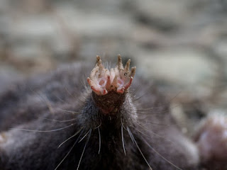
We have two species of moles in Chenango County, the Hairy-tailed Mole (Parascalops breweri) and the Star-nosed Mole (Condylura cristata). Both have hairy tails, but the Star-nosed has a long one. It also has a unique nose – 22 tentacle-like appendages surround its snout.

On Sunday 28 August 2016, we Bullthistle Hikers saw a dead Star-nosed Mole on Waldon Road in the Town of Smithville. It did not show any signs of trauma; it was just dead.


My notepad is 2 7/8 inches across. John Carhart measured the beast. It was 4 inches snout to tail and the tail was2 ¾ inches. John's close ups of the snout appear below.


This is our second Star-nosed in Smithville. The previous was on 2 October 2011 on State Route 41 through the Long Pond State Forest. It was smashed roadkill. On 15 March 2009 we encountered a live one running around on the grassy dam at Balsam Pond in Pharsalia. We enjoyed great views.

Star-nosed Moles live in moist soil, often near water. They eat earthworms and other invertebrates. They are good swimmers and can catch and eat small fish in muddy waters. The tentacles are sensitive tactile receptors and can sense electrical fields underwater.

Reference consulted:

Reid, Fiona A. Star-nosed Mole. In: A Field Guide to Mammals of North America North of Mexico. 4Th Edition. Boston, MA: Houghton Mifflin. 2006. Pages 389-390, Plate 34.

======

Wednesday, August 31, 2016

EXPLORING CHENANGO COUNTY BY HIKING -- AUGUST 2016


EXPLORING CHENANGO COUNTY BY HIKING – AUGUST 2016

Donald A. Windsor

The best way to explore Chenango County is to walk it. I lead hikes every Sunday morning, year around, for the Bullthistle Hiking Club and report them on our Yahoo group, BullthistleHikers, where the many photos posted by our hikers can be viewed. Here are my reports for August 2016.


7 August 2016 – Charels E. Baker State Forest, Columbus and Brookfield

Baker State Forest covers 9414 acres of woods punctuated by ponds, laced by streams, and knit together by several miles of horse/hiking trails. On Sunday morning 7 August 2016 we had 9 hikers in the southeastern chunk: Anne Altshuler, John Carhart, Warren Johnsen, Joyce Post, Art Sandberg, Sharron Sandberg, Carol Smith, Maryann Weiss, and Don Windsor. We covered about 5 miles in 3.5 hours for a speed of 1.4 miles per hour.

We parked in the lot on County Road 24 (=Shawler Brook Road) and hiked northerly to TT-1. We then trekked on T-17 to T-16 to Morrow Road, where we enjoyed our well-deserved break. Refreshed, we embarked easterly up a hill on what appeared to be an unmarked logging trail, but turned into a bushwhack through a horrific stand of vigorous blackberry canes growing up through the very coarse woody debris of cut off tree tops. In here I suffered a painful fall when a log I was clambering over suddenly snapped and I landed on more large branches. Score was now bush = 1, bushwhacker = 0.

We continued stumbling through until we reached T-15 and took it south and west to Morrow Road. We then went south to T-14 (=Pope Hill Road) back to our cars, posing for some group photos at the new kiosk and sign.


14 August 2016 – Beaver Meadow State Forest, Smyrna

The Beaver Meadow State Forest in Smyrna on Sunday morning 14 August 2016 was soaked from the storm the previous evening. Nevertheless, we had 4 hikers: Anne Altshuler, John Carhart, Peg Fuller, and Don Windsor. We covered 6.8 miles in 3.6 hours for a speed of 1.9 miles per hour. Our elevation gain was 1071 feet.

We parked in the quarry on Bliven-Coye Hill Road, east of Boos-Law Road, and hiked westerly to the state land. We then took the abandoned road, now snowmobile trail, south to George Crumb Road. We hike that west, but saw a lot of activity at the Y camp, so we took our well-deserved break on George Crumb and then took it northeasterly to our cars.

Rain held off until after our hike and the woods seemed almost bug free. Mud puddles were ample but not too daunting. Actually, it was a rather pleasant hike.


21 August 2016 – Pitcher Springs State Forest

A nice, bright Sunday morning 21 August 2016 progressively deteriorated into a gloomy, rainy one as 8 hikers ambled through the Pitcher Springs State Forest: Anne Altshuler, John Carhart, Peg Fuller, Tess O'Brien, Joyce Post, Art Sandberg, Sharron Sandberg, and Don Windsor. We covered 5.9 miles in 2.9 hours for a speed of 2.0 miles per hour.

We parked on Calhoun-Davis Road, just east of Kinney Road, and hiked west, pausing to pay our respects at the Soper Cemetery. Upon spotting an inviting snowmobile trail on the south side of C-D road, we yielded to the urge and took it. Good choice, because it was a dandy hiking trail. It veered southerly and then easterly and then formed a loop with the trail we had been on. We then returned to C-D and took it east to our cars.

The easterly snowmobile trek was on an old abandoned town road that once stretched between Mott Cook Road and Kostenko-Sutton Road. It appears as a dotted line on the 1944 topo map. We will investigate this stretch the next time we hike here, because it might afford a splendid loop.


28 August 2016 – Genegantslet State Forest, Smithville

A cool morning became hot as the sun beat down on 6 hikers in the Genegantslet State Forest in Smithville on Sunday 28 August 2016: Anne Altshuler, John Carhart, Joyce Post, Carol Smith, Maryann Weiss, and Don Windsor. We covered 7.2 miles in 3.8 hours for a speed of 1.9 miles per hour.

We parked on Stone Quarry Hill Road near the snowmobile trail and hiked east to Waldon Road. Whereupon, we ambled up Waldon north to the second creek, pausing for our well-deserved break. We then backtracked on Waldon south to Art Lake Road and took that to the snowmobile trail. We then trekked back southerly to our cars, gingerly sidestepping the numerous pesky mud holes.

We paid our respects at two cemeteries, the Eddy west of Waldon and the Perkins south along Art Lake. A dead Star-nosed Mole on Waldon provided a splendid photo op and John Carhart's close ups of the star tentacles are thought provoking.


========

Friday, August 26, 2016

MOST BEAUTIFUL STATUE IN CHENANANGO COUNTY


MOST BEAUTIFUL STATUE IN CHENANGO COUNTY

Donald A. Windsor

Could this stone angel be the most beautiful statue in Chenango County?


I think so.

It resides in the Chapel Cemetery on Cueball Road, just south of Wylie-Horton Road in the Town of Coventry.

However, beauty lies in the eye of the beholder. So, if anyone thinks there is a more beautiful statue, send me a photo + info and I will post them on this blog.

windsorda@yahoo.com
====


Tuesday, August 23, 2016

OAK-APPLE GALL

OAK-APPLE GALL

Donald A. Windsor

Oak-Apple Galls are formed by oak tree leaves under the control of the gall wasp Amphibolips confluentus, Family Cynipoidea. 


These two specimens were picked up under a Red Oak (Quercus rubra) in front of 51 Sheldon Street in the City of Norwich. I regret that I did not record the date, but it was the late spring or early summer of 2016.

The female wasp lays an egg on a leaf. The egg hatches into a larva that then feeds on the leaf, stimulating the leaf tissue to develop into a gall. The gall acts as a cocoon, protecting the larva as it pupates. When the pupa reaches adult stage, it breaks its way out of the gall.

Note the larval-pupal chamber suspended by fibers in the center of the opened gall.

Oak-Apple Galls have been found in several places in Chenango County.

Reference consulted:

Craighead, F.C. Leaf galls. In: Insect Enemies of Eastern Forests. Washington DC: US Department of Agriculture. Miscellaneous Publication Number 657. 1950. Pages 597-598.

====


Thursday, August 18, 2016

OLD CHERRY TREE IN MCDONOUGH


OLD CHERRY TREE IN MCDONOUGH

Donald A. Windsor

These photos were snapped on 17 July 2016.


Could this Black Cherry tree (Prunus serotina) be the oldest of its species in Chenango County? If not, please tell me about a competitor.

This specimen is along the Finger Lakes Trail in the McDonough State Forest, between Bliven-Sherman and Gale roads, about a stone's throw to the southeast. It is not readily noticeable; you have to look for it.

I first encountered this specimen back around 1997 and first photographed it for my article in The Evening Sun in 2002. Unfortunately, that photo is no longer available for reproduction here, but it does appear in the references below.

I identify with this gnarled old tree, because we are growing old together. Unfortunately, I suspect who will ultimately outlive whom.

References cited:

Windsor, Donald A. A gnarled survivor. The Evening Sun (Norwich, NY) 2002 April 15 Monday; 112(21): 17.
Windsor, Donald A. A gnarled survivor. In: Souvenirs of Yesteryear. Exploring Chenango County, New York. Norwich, NY: Self published. 2008 December 5. Pages 12-13.
=====